Pennine Journey Day 8 Wednesday 10 October 2012
High Force Hotel to Westgate in Weardale (12.4 miles - 1700 ft ascent)
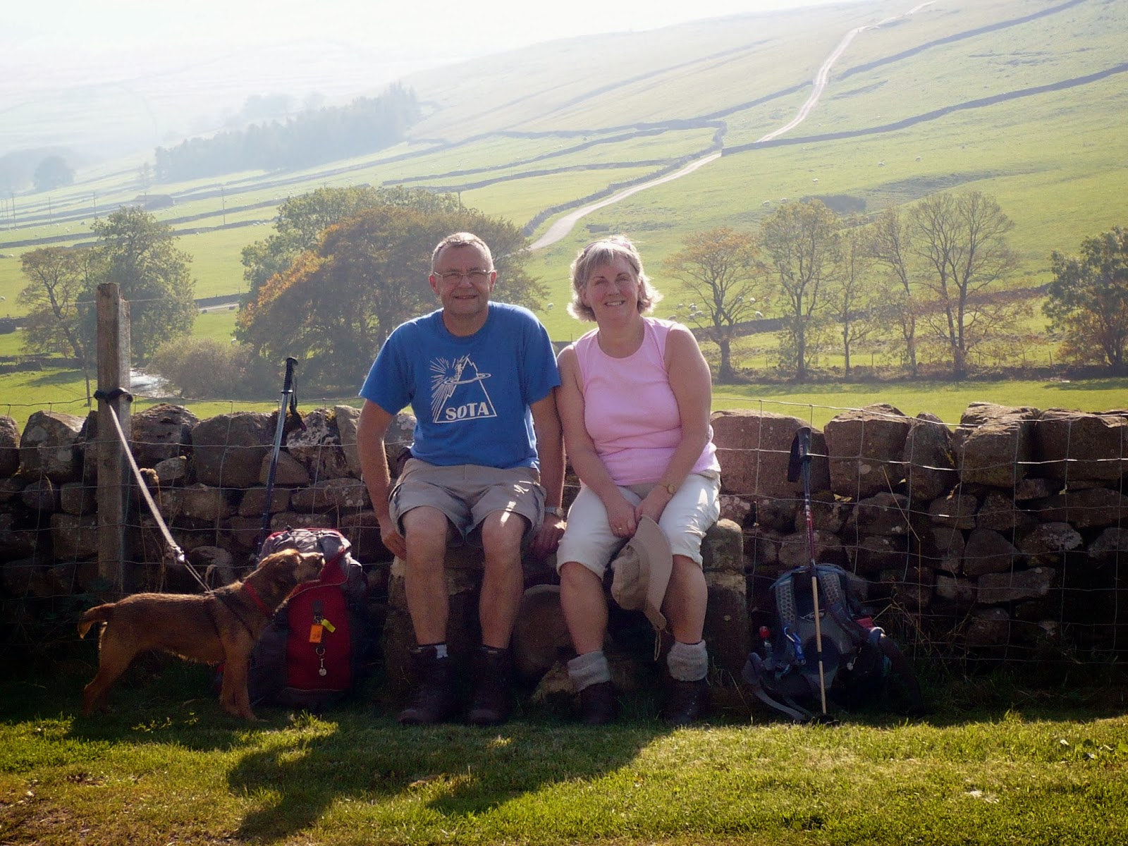
After finishing off the previous section of Wainwright's 247 mile 1938 Pennine Journey in April we restarted on Wednesday 10th October from the High Force Hotel. We planned to walk for five days up to Hexham, on to Hadrian's Wall and then across to Once Brewed. As it happened we got further than that and on to Greenhead on what was an eventful walk. Jennie who accompanied us on our previous legs, had to back out on this section due to her work commitments so her place was taken up by our good friend Chas. So for this section it was Phil, Judy, Geoff, Yvonne and Chas who restarted from High Force on a sunny morning making for Westgate in Weardale. It was after 11.00am when we started our walk. We had driven to Lands Farm (B&B) at Westgate in Weardale in two cars, parked Yvonne's car there and then had driven down to the High Force Hotel in mine.
 |
Yvonne - Chas - Judy - Geoff - Phil (Writer)
To get back to the point where we had left the route in April meant we had to walk just over a mile to High Force and pick up where we left off. This was great for Chas who got a chance for the first time to see High Force in spate (see earlier picture). The area around the force contains Juniper and to prevent contamination by a disease walkers are required to disinfect their boots when entering and leaving the site. Here you can Judy and Chas cleaning theirs:
|
After the boot wash the route followed the River Tees up to cross it at Cronkley Bridge. When we reached Saur Hill Bridge we left the Pennine Way as the Pennine Journey continued east to Hanging Shaw, a deserted farm which was still inhabited with hens. We were to see many more derelict farmsteads on our way through the North Pennines up to Hadrian's Wall.
 |
| An old water well pump at Hanging Shaw - a derelict farm |
At Scar End a minor navigational error was made which was soon corrected and we proceeded north over the pathless moorland towards the hill called Black Law (576m). Our Pennine Journey guide book written by David Pitt suggested that we look out for a ruined shooting hut of stone and rusty red corrugated sheeting. We found it:
 |
| Yvonne - Chas - Judy - Geoff at the "Shooting Cabin" below Black Law |
And so we continued across the pathless moor to the public road at Swinhope Head, this was easily picked out by the prominent power line with two poles located by the cattle grid at Swinhope Head which made navigation easy. We then used the road and a short section of track near a remote shooting clubhouse south of Swinhopehead House to take us to Westgate. Chatting to locals later we discovered that the much of the grouse moor in the area is owned by shooting enthusiasts from the middle east! Most surprising.
At 4.50pm we arrived at Westgate. I crossed the River Wear by the ford (as you do) and took this picture of the other members of the group on the footbridge above it:
Westgate is a strip village which dates back to the old lead mining days. Today there are cottages, farms, a couple of camp sites, a pub and a small Co-op. The pub is the Hare and Hounds and we had an reasonable pub meal there later that evening. The pub no longer offer accommodation - this is down to the increasing "red tape" and fire regulations relating to offering guest accommodation. It is simply too expensive for small pubs to meet the requirements and still make a profit. This worked in our favour as we found a super affordable B&B at Lands Farm less than half a mile south of the pub. Read my review here on Trip Advisor.
 |
| A good pub at Westgate in Weardale |
Barbara Reed at Lands Farm looked after us well and made us some sandwiches to see us through the second day of our journey north to Blanchland. Once again we were making use of the bag carrying services provided by Brigantes who provide an efficient service. They collect the bags at 9.30am or later and guarantee to have them delivered at your next overnight stop before 4.30pm.
Day 9 Thursday 11 October 2012
Westgate in Weardale to Blanchland (11.5/13 miles - 1450 ft ascent)
The expected mileage today was 11.5 miles however as can be seen above we managed to complete 13 miles. The writer lost concentration after we climbed the Boltslaw Incline and we went staright on. More on that later.....
The further north we walked the more interesting the walk became. Today we saw many industrial relics of the past as we moved from the Durham Dales to enter Northumberland at Blanchland. We climbed out of Westgate in good October weather, perfect for walking. Leaving Lands Farm at 9.30am very well fortified after an excellent breakfast we reached the busy Heights Limestone Quarry, where the path (Pennine Journey & Weardale Way) had been safely diverted and well marked out:
 |
| Heights Quarry above Weardale |
I think I will add the 77 mile Weardale Way from Killhope to Roker to my "to do" list. This section was lovely as we now made our way with the far reaching views to our right along a former tramway with woodland, cuttings and embankments on our way to the (partly ugly) village of Rookhope. Maybe I am being as unkind to Rookhope as Wainwright was to Weardale when he wrote about it in his 1938 work Pennine Journey.
When we reached Park Burn at grid ref 921388 we were surprised to find a deep gorge, obviously previously crossed via a tramway bridge, now gone. We diverted to the right and crossed the gorge with little difficulty. After crossing I checked David Pitts guidebook and he suggesting crossing to the left....I'm now sure that either side of the gap will enable progress to be made! Going NNE we passed an area called Hanging Wells - there must be some history in that name. Once again the occasional derelict farmstead appeared. This one is shown as High Bishopseat on the OS Map:

After passing an engineering business we crossed Rookhope Burn via a road bridge to enter the village centre of Rookhope (locally pronounced as Rookup), which was quite pleasant, with a pub which also offered tearoom facilities during the day. We had our own provisions and so we sat in the village bus shelter where we had a coffee break. There are also clean public toilet facilities available in the village. The former mining tramway is remembered by one of the wagons which is mounted in a prominent position in the village:

We now made our way now on the Sustrans C2C cycling route up the Bolt's Law Incline which took us to an height of almost 1700 ft. A lone cyclist passed us as we started the climb from Rookhope but he had to dismount shortly after passing us as he wasn't up to climbing the incline. We were going well with our "pilot" Geoff well ahead of us on the ascent. At one stage I thought Geoff would catch the walking cyclist as he had him in his sights, however the rider got back on his bike when the incline shallowed off and he disappeared over the top out of view.
|
Information board - top of Bolt's Law Incline
I didn't take a photo of the remains of the engine shed for the Bolt's Law Steam Engine, but it is worth a look around if you have an interest in our industrial heritage. The substantial walls of the shed and terminus have been restored over the last few years. The walls would make a good windbreak and lunch spot. We decided not to go over the summit top of Bolt's Law (I now wish we had done!) but instead continued on to see what was going on ahead. From Bolt's Law a track continues east to join the Blanchland to Stanhope road at Dead Friar's Stone. There was serious work in progress here so I put away my map and PJ guidebook as Geoff chatted to the foreman of the team working on the track. We discovered that the team of men were excavating stone from the nearby Dead Man's Quarry and bringing it back to rebuild the road surface. The foreman told us that the estate owner was investing in improving the access to the grouse moor. Well, the grouse were certainly there - we saw lots.
 |
 |
| We proceed - but not on the Pennine Journey route! |
After continuing on the track for about 3/4 of a mile I decided to check the map and my GPS compass and realised we were heading east - the wrong direction, a mistake which cost us 40 minutes and down to me as the leader of the group. After checking Pennine Journey I realised we should have turned left at the Sheepfold where Geoff had chatted to the foreman, rather than continuing on the improved track. As we returned to the correct route we caught sight of the former Silkhead Lead MInes western chimney, a prominent landmark on our route which we made for. It was getting colder now and it had started to rain a little:
 |
| Near the west chimney at Silkhead lead mine |
From the west chimney our route was less clear and I couldn't grasp the instructions in our Pennine Journey guidebook. My Garmin Etrex GPS wasn't much help either. I had downloaded the route from the LDWA website and their version of the route was not in accordance with the guidebook. We could see several derelict farms and buildings below us and what looked like a railway goods wagon top, so we made for that. This turned out to be a sealed off mine shaft and this was shown on the OS map as "shaft". We had detoured west of our intended route by a few hundred metres, however after climbing over a low fence we joined a track going north for 200m to recover our intended route at the derelict building on the mine road which is mentioned in the PJ guidebook. We then stopped for lunch under the shelter of some trees as it was still raining lightly.
The public road is joined at a hairpin bend and followed for some distance before we turned off to continue in woodland for almost two miles into Blanchland. Initially the woodland path above Bolt's Burn was quite waterlogged in places.
 |
| Judy looks quite shocked as we enter Northumberland at Blanchland! |
I had previously read that Blanchland was a lovely village. Ancient, almost medieval and rather like the Cotswolds. and this proved to be correct.
 |
| Entering Blanchland |
We made for the White Monk Tearooms at the top of the village for a cream tea, passing the now closed Grade One Listed Lord Crewe Arms Hotel. A local told me with a degree of scepticism that the new owner of the hotel lives in the south and that he wanted to make improvements to the hotel to bring it up to a very high standard which would appeal to the shooting parties who visit the area for the grouse and pheasant shooting. If this proves correct the hotel won't be much use to walkers passing through on Wainwright's Pennine Journey - too expensive and totally inappropriate!
 |
| The now closed (Pictured in October 2012) Lord Crewe Arms Hotel |
We had arranged to stay at The Punch Bowl (Trip Advisor link) in the village of Edmundbyers, five miles towards Consett from Blanchland. The fine landlord there, Chris Brown had offered to collect us and return us to Blanchland the next morning, so we needed to phone him. Blanchland is a black hole for mobile phone reception. Neither, Vodafone, Orange or O2 worked. The phonebox was also out of order and it looked like it had been for some time. Our only option was to return to the tearoom and offer them a 50p tip and ask if we could use their phone, which they kindly allowed us to do. Chris Brown was with us within 15 minutes and I volunteered to ride in the 4X4 car's boot as we were six up. It was a rough ride....experienced by Geoff on the return trip.
 |
| The Punch Bowl Edmundbyers |
The Punch Bowl Inn was an excellent pub and we hit it on a busy Thursday - the quiz night! This was great fun. We managed to get 27 out of 40 questions correct but didn't win unfortunately! Our meals were excellent, you don't get better in a pub. Next morning the breakfast passed muster, only the best local produce being used. The rooms were adequate although on the small side. Read my review on Trip Advisor (Pending).
Day 10 Friday 12 October 2012
Blanchland to Hexham (12.2m - 1250 ft ascent)
Punch Bowl landlord Chris Brown bid us farewell after returning us to Blanchland at 9.55am - what a great guy. We headed northwest on a sunny day up the tarmac drovers road to Hexham. The hamlet of Shildon is soon reached, a cluster of former lead miners cottages. Shortly after Pennypie House comes into view - an old Coaching Inn set above the road. Here the tarmac ends as you reach the track crossing Blanchland Moor.
 |
| Geoff approaches Pennypie House |
The two mile walk over Blanchland Moor was enjoyed by us all. The grouse were prolific, the track was good and we had excellent views to Derwent Reservoir to the east. We entered Slaley Forest, a place I had visited years ago. Around 1980 I recall meeting Lionel Blair in this forest. I was up there watching a car rally in the forest. Around that time Lionel was navigating on car rallies in a Triumph Dolomite. It happened that the car broke down right in front of where four of us were spectating and we gave the crew a push! I've met very few famous people, but I met another two on this trip. You will have to wait until Day 12 to find out who they were, so read on!
 |
| Judy - Yvonne - Chas - Geoff in Slaley Forest |
Our walk continued through several miles of woodland. Part of Slaley Forest has been felled, but there were more woodland paths through to Redlead Mill and onwards towards Hexham.
 |
| Track going west in Slaley Forest |
Navigation needed to be perfect today after my error the previous day, so the map was never out of my hand as we searched for somewhere to eat our lunch. Redlead Mill was found after we emerged from Steelhall Wood. There was no mill there, just a rather nicely sited cottage. Our guidebook said we would shortly come across some gothic arches - a remnant of the Dukesfield Smelting Mill. Sure enough we arrived there for lunch just before 1.00pm. This marvellous piece of decaying architecture is at grid reference NY 941580 and is not named on the map. It really is worth visiting and is sited near to where Hall Burn meets Devil's Water.
 |
| One of two Gothic Arches - Dukesfield Smelting Mill |
A climb through National Trust owned woodland brought us to the village of Ordley were some modern stone built houses had been built. The path here was hidden and ran down the side of one of the houses. There was no waymark. The path existed long before the houses were built. Hopefully when the Pennine Journey Supporters Club waymark the route in 2013 this point will receive attention. A road section came next and an interesting path which was routed to the side of Hole House, where we paused for a drink. Soon we were crossing a road near a covered reservoir and there was Hexham below us.
 |
| Field path downhill to Hexham |
.JPG) |
| Hallbank Guest House Hexham |
The final path down to the road running into Hexham was extremely muddy. The wet summer and grazing cattle make for heavy going, but we got through the mud and had walked most of it off our boots as we entered Hexham. Judy bought some walking socks in Mountain Warehouse as we strolled around the town until we found a cafe that was happy to allow us in despite our filthy boots. We enjoyed chatting to some locals who were genuinely interested to hear about the Pennine Journey so we did a little PR. The cafe owner told us about an nearby Italian restaurant called Quattro Mori and we eat there that night and the following night. It was excellent in every way. The same cannot be said of our experience at Hallbank Guest House, where we stayed for two nights. You can read my reviews on Trip Advisor.
Day 11 Saturday 13 October 2012
Hexham to Housesteads Fort (16.2 miles - 2000ft ascent)
 |
| The River Tyne at Hexham Bridge |
We left Hexham to cross the River Tyne at 0940am in good weather on our way up to Hadrian's Wall at Planetrees. Our initial plan was to walk around 11 miles to Brocolitia Fort and then catch the AD122 bus back to our guest house in Hexham. The plan changed however during the day. We walked through the old part of Acomb village, north to Fallowfield and took a path to east of Crag House where they farm Alpacas. These delightful and most curious creatures came to greet us as we used the path running alongside their field.
 |
| We were greeted by around 30 Alpacas at Crag House! |
As we left the Alpaca field we could now see the wall. It had been a long time coming - 11 days, a slower schedule than the one travelled by AW in 1938, but now we were at last about to invade the wall! A section was visible at Planetrees but this soon disappeared as we made a detour towards the village of Wall before heading for Chollerford on the North Tyne where we crossed the bridge by the weir.
 |
| Chollerford Weir on the River North Tyne |
 |
| Interesting fungi by the wall |
At Chollerford we stopped off at the Riverside Tearooms for refreshments, before continuing along the B6318, which is the road which runs alongside this section of Hadrian's Wall. We rejoined the Hadrian's Wall footpath beyond Walwick when the going got rough. With having had such a wet summer the conditions of the footpaths was bad, and this was mainly due to poached ground caused by cattle grazing on the land adjacent to the wall. We soldiered on though towards our intended destination of Brocolitia. As we had made good progress we decided to review the bus timetable. A unanimous decision was reached that we should continue onwards to Housesteads, and then catch the 5.34pm bus back to Hexham from there. This would mean that on our next and final day for this leg we could reach Greenhead, which is the point where the Pennine Journey leaves the wall and goes south to Alston. As we had all enjoyed a toasted teacake and tea at Chollerford we were able to continue and have our lunch at 2.00pm when we arrived at the Brocolitia Fort.
 |
We walk past the remains Brocolitia Roman Fort
At Sewing Shields we could see why Hadrian had built the wall here. For some distance the wall sat upon natural crags with a considerable drop to the north - a natural defence and we found next day that this continued on and off right through to Greenhead.
|
 |
| Saturday on the wall Geoff - Chas - Yvonne - Phil (Writer) - Judy |
We reached Housesteads at about 4.30pm and found that the attendant had knocked off for the day. This also meant that when we reached the visitor centre and car park the toilets and refreshment counter were also closed. Come October they close at 4.00pm. On this day they had undoubtedly lost some considerable trade as there was a large group of around 20 foreign students waiting for the bus and several car loads of people who were setting off to look at the fort and wall, which lies about 500m from the car park.
 |
| Information board at the bus stop on Housesteads Car Park |
Our return to Hexham was later than anticipated so we rearranged our meal booking at Quattro Mori for 7.30pm. The AD122 bus drops off on the car park adjacent to Waitrose in Hexham so we all nipped in and purchased sandwiches for the following day before returning to Hallbank Guest House to get cleaned up.
Day 12 Sunday 14 October 2012
Housesteads to Greenhead (10.6 miles 1500 ft ascent)
 |
| Bill Bryson |
An early breakfast was ordered at the Hallbank Guest House for 7.30am. The timing was essential as we had to vacate our rooms and catch the 0905 am bus from the Hexham tourist back to Housesteads. I noticed a familiar face at breakfast, someone who was famous. It was Bill Bryson OBE, the best selling American travel writer, and yes, he was actually writing as he enjoyed his breakfast. We got a "good morning" and a smile out of the author and let him get on with his breakfast. Bill wasn't the only famous person we saw this day - we encountered Stephen Gough, otherwise known as the naked rambler, who came up behind us on the wall near Once Brewed!
The section of the Hadrian's Wall National Trail from Housesteads Fort to Greenhead was very well maintained and unlike the previous day, few animals had been grazing along it, so our route was in better order. As it was Sunday there were plenty of people walking on the path, which again followed the top of crags over much of its length. This meant the walk was quite challenging with lots of dips to descend and banks to climb. There was a sponsored walk taking place with walkers from the Newcastle area. We also met two very large groups of young army cadets being guided by experienced walk leaders. The sponsored walkers had started from the Once Brewed Visitor Centre, which is some distance away from the wall and a place which we must visit another time. Half a mile west of Housesteads we again met The Pennine Way near Cuddy's Crags, where the PW turned north to head to its destination of Kirk Yetholm. We were to stay with the PW until the end of our day at Greenhead.
 |
Hadrian's Wall Trail meets The Pennine Way near Cuddy's Crags
L-R: Geoff, Phil (writer), Judy, Chas, Yvonne |
We were doing well although Judy was suffering with a large blister on her heal. She had been brave enough to tackle this last day, albeit with some trepidation, by applying two Compeed blister plasters, although she was experiencing some discomfort it has to be said.
The area around Crag Lough was impressive and very picturesque, and the wall had been rebuilt here, although it was less substantial than the sections we saw the previous day.
 |
| Hotbank Farm and Crag Lough |
We stopped for refreshments and took stock of the things we had found on this 5 day 64 mile section of Pennine Journey:
- A Cardigan
- A £1 Coin
- A bin liner under a hedge containing about six "mucky video's"
- A Hat
- A Scarf
- Two pairs of socks (found in different places)
- A dog lead
 |
The naked rambler
leaving the wall |
All the above were left were we came across them, apart from the £1 coin which was found and kept by Yvonne at the Housesteads Fort bus stop! A short distance from Caw Gap where the wall crosses a minor road I heard a walker approaching from behind. I turned round and to my amazement it was The Naked Rambler. I just said "Good Morning, it's the Naked Rambler" to warn the others in the party. The ladies glanced round briefly and got an eyeful as we continued on our way, with me chatting to the activist, about how he washes his socks, the use of walking poles and his problems with the police. He told me he had come down from Edinburgh and was going south. I later found out he had been released from Edinburgh Prison the previous week where he had been serving yet another term for breach of the peace. Prison is something he has grown accustomed to in his determination to exercise his right to walk naked around Britain, having served around six years in custody! As we dropped down to Caw Gap our pace increased as the two ladies did not wish to be overtaken by our new found friend. In her efforts to descend quickly Judy slid sideways and barrel rolled once, fortunately without injury. When we reached the lane at Caw Gap the naked rambler turned left to head for the B6318 saying he was "cutting a bit off". It was quite an experience meeting him as you can imagine.
 |
| Looking back to Crag Lough |
Our Pennine Journey Guidebook mentioned that there was a picnic area at the former Cawfields Quarry and it was a good place for us to stop for lunch with picnic tables and toilets.
 As pathfinder I made a minor navigational error just west of Walltown Crags near a car park and left the wall to follow a track for 300m. We rejoined the national trail as we approached Hole Gap where there was another old quarry with a lake, and cafe. It was after 3.00pm when we arrived here and with our taxi booked at Greenhead over one mile away for 3.45pm we did not have time to stop for refreshments. Continuing on we reached Greenhead in the middle of a heavy shower at 3.40pm with our taxi (Advanced Taxis of Hexham - good service and price) already waiting for us, which meant we could not sample the tearoom at Greenhead either.
Our journey by taxi back to Westgate was via Hallbank Guest House in Hexham to collect our bags. We then proceeded through the now familiar Northumberland and Durham country and moor to Lands Farm at Westgate where we had parked our cars four days previously. After saying our goodbyes to Chas and Yvonne, Phil, Judy and Geoff motored down to The Three Tuns public house in Thirsk for a roast dinner before proceeding back to Pickering. Geoff returned to his home in Malvern the following day.
We plan to continue our Pennine Journey in April 2013 by walking south from Greenhead down to Appleby. Our intention is to complete the 247 mile walk before September - 75 years after it was walked by A Wainwright.
Link to: Greenhead to Appleby ......


![[image]](http://imageshack.us/photo/my-images/809/ladgill2.jpg/ "[image]")
![[image]](http://imageshack.us/photo/my-images/812/tanhilllunch2.jpg/ "[image]")
![[image]](http://imageshack.us/photo/my-images/23/bridgeatweirnearladymyr.jpg/ "[image]")
![[image]](http://imageshack.us/photo/my-images/819/leavingbridgeatladymyre.jpg/ "[image]")
![[image]](http://imageshack.us/photo/my-images/507/lunchongoldsborough.jpg/ "[image]")
![[image]](http://imageshack.us/photo/my-images/259/middletoninteesdaleinsi.jpg/ "[image]")
![[image]](http://imageshack.us/photo/my-images/28/highforce.jpg/ "[image]")


.JPG)


